Throughout history boundaries have had the potential to lead to full-blown disputes. These have ranged in scale from wars involving powerful nations, to bitter long-term feuds between next-door-neighbours. Mapping boundaries in black and white is an important part of risk reduction, and even then it does not always work.
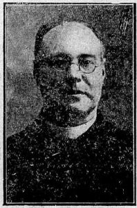
Ironically, as the Great War was drawing to a close with the resultant redrawing of many country borders, on a far smaller level the Batley St. Mary of the Angels parish boundaries were exercising the minds of both the Bishop of Leeds, Joseph Robert Cowgill, and parish priest Fr. John Joseph Lea (left).
The latter had been tasked with finding a map depicting the extent of his parish. As a letter dated 19 November 1918 from Fr. Lea to the Bishop indicated, it was a task in which the parish priest failed. But in its stead Fr. Lea did provide a valuable alternative, in the form of a detailed written description. I’ve reproduced this description in full, below.
My Lord
I have tried to procure a map of the district, but I have been unable to secure one. I send a detailed description of the Batley parish’s boundaries as given to me when I came to Batley in 1899, and which have been used since I came here. They may not be perfectly accurate as regards the line between Batley and Morley. I doubt if any real line was given by authority.
Lee Fair, Woodkirk, up to West Ardsley probably being the only description of the division, the first and second place being described as belonging to Batley.
Boundaries of the Batley Parish
I. Between Batley and Birstall (working assumption)Starting around White Lee at the cross roads on the old Leeds Road leading from Birstall, a straight line drawn through the small street called White Lee Road across the Bradford Road, through Brookroyd, thence by the same straight line across the Upper Batley Lane till it meets the stream called Howley Beck in the valley. (NB The whole of Brookroyd was considered as belonging to Birstall).
II. Between Batley and Morley
Along this stream (Howley Beck) from the point just mentioned above till it meets Scotsman’s Lane at the West End Colliery siding. From this point I believe it goes by a straight line below Howley Ruins through the fields until it meets Rein Road north of Woodkirk somewhere about the point where Rein Road meets the Leeds Road. Thence along the road that leads to West Ardsley where Batley parish ended. (West Ardsley not included).III. Between Batley and Batley Carr.
From the Halifax Road Road at Staincliffe close to where Deighton Lane meets and crosses it a straight line is drawn through the fields, along through Oxford Street at Mount Pleasant, through the Football and cricket fields till it crosses the Bradford Road at Knottingley Wells. Knottingley Wells Public House being the last house in Batley Parish at this point, thence across the Bradford Road to the road and along this road leading under the Railways to Grange Road. Up Grange Road till it meets Leeds Road and thence in a straight [line] across this Leeds Road in the direction of West Ardsley.[IV.] Between Batley and Heckmondwike
From the point where Deighton Lane meets the Halifax Road at Staincliffe along Deighton Lane till it meets Healy [sic] Lane, turning to the left a short distance on the Healy [sic] Lane it crosses this lane at the footpath and along this footpath through the Jail till it meets White Lee Road. Thence along this White Lee Road till it reaches the cross roads at White Lee on the old Leeds Road, the point where Batley and Birstall meet.These are the Boundaries, I was given to understand which existed between the different parishes when I came to Batley. That between Batley and Birstall was an arrangement until settled by authority.
Nov 19th 1918. John J. Lea, St Mary’s Batley
From this description those who know the Batley/Birstall/Batley Carr/Heckmondwike areas can picture the boundaries. That White Lee Road was described as a ‘small street’ might give some pause for thought.
In particular I find it interesting realising streets I knew from my childhood had not been built at this point.

For example, if you read the description of the boundary between Batley and Heckmondwike, and look at the above map from the period Fr. Lea was writing to find the footpath leading to the Jail, you will notice no Mortimer Street; Mortimer Avenue has not yet been complete; and no Mortimer Terrace. The footpath runs through the Back Fields of my childhood, now long gone. I can also remember playing in the Jail ruins, now also gone.
Postscript:
I may not be able to thank you personally because of your contact detail confidentiality, but I do want to say how much I appreciate the donations already received to keep this website going. They really and truly do help. Thank you.
The website has always been free to use, and I want to continue this policy in the future. However, it does cost me money to operate – from undertaking the research to website hosting costs. In the current difficult economic climate I do have to regularly consider if I can afford to continue running it as a free resource.
If you have enjoyed reading the various pieces, and would like to make a donation towards keeping the website up and running in its current open access format, it would be very much appreciated.

Please click 👉🏻here👈🏻 to be taken to the PayPal donation link. By making a donation you will be helping to keep the website online and freely available for all. Thank you.
As a professionally qualified genealogist, if you would like me to undertake any family, local or house history research for you do please get in touch.
More information can be found on my research services page.
